
[YouTube]
I get a lot of emails from people in Lebanon asking me to review their apps, and what I usually do is download the app, try it out and write about it if I think it’s a nice and promising one. However, I decided to sit and talk with the guy behind Tari2ak, Rami Khawandi, before posting because his idea is a very smart one and hard to implement so I wanted to know how he made it possible.
[Tari2ak] is basically a mobile app that uses your smartphones as sensors to detect your movement activity (using an AI algorithm) and then detects your location using GPS to report real-time traffic conditions. All is done passively without any effort or human intervention, and without the need to have the app open even. To put it in simpler terms, any user who has the app installed will be transmitting information regarding traffic without having to do anything or draining his battery, and the Tari2ak servers will handle all the traffic reports and update the maps accordingly.
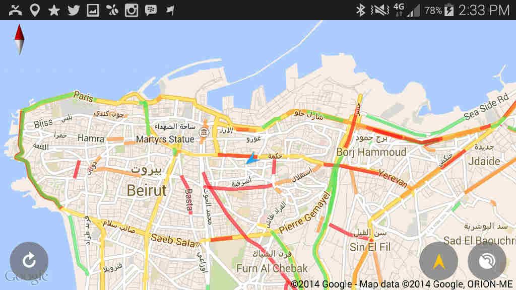
What you get as a result is a map like the one shown above, with lights indicating the traffic status. Generally, a green traffic line means the average speed on that street is above 40 km/h, orange indicates the average speed is between 20 km/h and 40 km/h, and red is below 20 km/h. There are cases like small streets or big highways were those numbers vary a little.
This is a brief overview of the app but I do recommend that you read the Q&A below as it covers most of the questions you might have in mind, specially the ones related to Google traffic and how the app detects your motion. For those of you who are too lazy to read, you can watch the brief walkthrough video for the user experience and the app in general that was exclusively made for BlogBaladi.
[Tari2ak] has 1500 daily active users and is available for [iOS] and [Android]. It’s a very promising app with a lot of potential, specially in countries like Lebanon with no Google Traffic data available and no government APIs to rely on.
So hurry up and download it because winter is coming (Hello GOT fans) and you will need it with all this traffic!
What is Tari’ak?
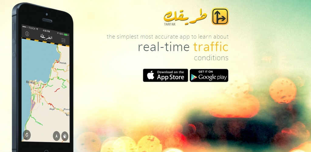
Tari’ak is a mobile app that we claim is the simplest most accurate way to learn about real-time traffic conditions, currently available in Lebanon.
How did you come up with the app? Is the app for free or are there any paid versions?
People who work in tech, and software engineers specifically, are constantly on the hunt for the next great idea. It can get very obsessive sometimes because solving a real-life problem is the equivalent of painting the Mona Lisa for us nerds.
It started while I was discussing app ideas with a friend of mine while driving in Beirut, and as you would expect, we got caught in a heavy traffic jam on a road we could have easily avoided if only we knew it was blocked. We then started thinking about how we could possibly avoid traffic jams using smartphones and checked out existing traffic apps but none of them was of any practical use. I spent the next month doing the research and when I finally figured out a better way to crowdsource traffic, I committed to this idea as my senior project. So I guess you can say the idea came from a cocktail of frustration, optimism, and commitment.
Tari’ak is a free app and will continue to be so.
How many users do you have till now? How many active ones daily?
So far we’ve had more than 20,000 downloads and among them are 1500 daily active users, and over 9500 active monthly. Note that we have just launched our Android version last week so the numbers are going up fast.
Each day we receive about 9000 traffic reports from around 1300 streets, and these numbers have doubled since last month. This is only for Lebanon.
Other than downloading the app, do users have to do anything manually? How does it work?
Users can use the app without giving us any information. Our solution crowdsources traffic data passively and is completely automated. We believe users should not report traffic manually for these main reasons:
1- There is no incentive for the user! Informing others about traffic conditions is not the first thing that’s going to come to your mind when you’re stressed or late.
2- People lie!! With manual reporting of traffic, there is no proof-checking. A bunch of friends can choose to misinform the public just for fun… so forget about reliable data.
3- Most importantly, it is not road-safe!!! Prompting users to tell us about traffic manually compromises their safety if they’re driving. We care about people and advise them to avoid distractions when driving.
How Tari’ak works is simple: people move while carrying their phones. That’s really all it takes.
The app wakes up (in the background) whenever you start moving and intelligently identifies your movement activity (walking, running, biking, in a vehicle, on a motorbike, etc..) using an AI algorithm that relies solely on your device’s motion sensors (accelerometer and gyroscope,) not the GPS, in order not to drain the battery. The algorithm works in a similar fashion to fitness apps that measure your steps and it has proved to be pretty accurate.
Once the app knows that you are driving, it then activates the GPS for a few seconds to get the device’s location, speed and direction, and reports this info to our server. All this is done passively without any effort or human intervention, and without the need to have the app open even.
Accordingly, our server is continuously (24/7) receiving speed measurements from people driving, and it can therefore calculate the average speed of each road users are driving on. If that average is low, then there is heavy traffic.
How do u know if someone is walking slowly or driving in traffic?
Most people assume that we detect the type of movement using the speed of the device. We don’t. We rely on motion metrics instead. For example, the acceleration of a car is unmatched by that of a person or a bike, where as the shaky movement of the device in a pocket or purse of a pedestrian is not the same as its steady movement when placed in a car. This is, in simple terms, how the app knows when the smartphone is in a vehicle. Once the movement changes from vehicle to pedestrian then the app assumes that the user has left the car, and takes this as a cue to go back to sleep.
What about privacy? Do you track where people are going?
We get asked this all the time. No we don’t! The app does not collect any information that can identify who you are as a person: no name, no e-mail, no Facebook, no phone number, nothing. Therefore, our system knows that some smartphone is in a car at this road at that speed, but can not know who the owner of the device is.
Using Tari’ak is completely anonymous. The app does not require any registration or log-in. You just download it and use it right away.
What do all the colors mean? Are they computed as an average and how frequently?
Our server re-computes the average speed for a street every time a new report arrives from a device on that street. That is how we manage to keep our data in real-time. Some busy streets get several reports per hour, where as some less dense streets get a few per day.
Generally, a green traffic line means the average speed on that street is above 40 km/h, orange indicates the average speed is between 20 km/h and 40 km/h, and red is below 20 km/h. There are cases like small streets or big highways were those numbers vary a little.
How often is the data updated on the maps?
The traffic data you see on the map is automatically refreshed every 3 minutes, though the user can choose to refresh it at will using the ⟲ button. The data you see on the map can be a few seconds ago, several minutes or a maximum of one hour old in order to ensure that you do not see any outdated traffic data.
Does the app affect my battery life anyhow? Last thing I need is another app that kills my battery!
One of the things we test most is battery consumption. Tari’ak is very light on your battery because it only uses the GPS for a few seconds every several hundred meters, and only when you’re driving! So if you have your phone on a desk all day, the app will not consume any battery. This is possible because we rely on motion sensors and not the GPS as stated above.
In one of the early iOS versions, we got some complaints about battery usage from people using iOS 5 due to an unattended compatibility bug. We quickly fixed that with an update and we’re happy to say there have been no complaints about battery usage ever since. Bear in mind that we use the app ourselves and don’t want our batteries dying either!
Can we plan an itinerary on the app?
Not at the moment, no.
What is your business model?
The app itself is, and will remain, free for users to benefit from. We don’t believe people should pay money in order to be able to avoid traffic. Our business model is an intermediary one, and lies in selling a live feed of traffic data to non-competing media such as TV networks and radio stations. We also aggregate historical traffic data and make it available for a fee to interested organizations such as NGOs, urban development organizations, and government ministries.
What are your future plans? New features to be added? Are you planning to expand in other countries?
We’re constantly thinking of new ways to build on top of our traffic data and provide a more valuable experience for users. We are also interested in licensing our traffic data to third parties that can find new uses for it. Future features might include routing based on traffic estimates, and optionally notifying users about nearby traffic jams, yet we have no time estimate when those features might arrive.
We definitely want to expand to other countries and right now we are setting up the technical infrastructure to do so, as well as exploring potential markets to better our understanding on how to enter and who to partner with.
Did any foreign or local companies show interest in your app?
Oh yes! At first I naively thought that traffic was a uniquely Lebanese problem, but people and organizations from all over have expressed interest in Tari’ak as a low-cost solution to crowdsource traffic, especially that it could reveal hidden insights and transportation patterns when you analyze this big data.
I’ve seen a lot of interesting startups that die out after few months or even weeks. How serious are you about this app? And how much time and money are you investing in it?
You’re right. Some very promising startups ended up dying mostly due to lack of funding, inability to scale, or lack of market demand. We don’t know what the future has in store for us but so far our journey has been a positive one.
Personally, I started working on this app about 18 months ago. About 4 months ago when things started getting serious, I quit my job and dedicated myself to Tari’ak full-time. At the risk of sounding silly, I just jumped in the water to see if I could swim. Entrepreneurship is not easy! My opinion is that entrepreneurship is a romanticized idea and entrepreneurs don’t really know what they’re getting into. I didn’t either at the time, but I simply thought that I would rather regret doing this than not doing it.
Time has been kind with us so far though: our user base is growing rapidly, our data is proving to be accurate, we’ve been able to garner interest from investors and media companies, and what started as my tiny project is now a team of 4 people working on 2 mobile platforms along with business partners to make navigating through traffic in Lebanon a little bit easier 🙂
As for investment, well, anyone would tell you that Lebanon lacks a proper financial foundation for a healthy startup ecosystem, but some recent developments make me believe that that is changing. For us, we’ve been talking with angel investors as well as VCs for funding, and have received several investment opportunities so far but I’m afraid I’m unable to disclose more details due to legal agreements. We’ll make sure to announce any updates when the time is right.
How is Tari’ak different from Google Maps?
A simple answer is that if you open Google Maps it won’t show you the traffic conditions in Lebanon where as Tari’ak has a populated traffic map 24 hours a day. Google Traffic does crowdsource their data but they also rely on government APIs where available. This might be the reason they don’t support Lebanon but this is just a speculative answer. Also, one of the things we do that Google doesn’t is that we have an API to export our traffic data so that third parties can build on it where they see valuable.


Love IT … and gona recommend it so it will be more accurate:D
looks exciting… Lolz for Winter is coming!
All in all, does it work?
No one knows… you’ll have to give it a try
Great app.
Been using it for a while now. It’s accurate enough (15min to 1hr range) to give you the chance to avoid heavy traffic.
With more people using the app, the accuracy will increase.
A thumbs up.
Good job!
Doesnt google map give you real time traffic 2? I know i used it in italy 5 months ago…. really useful
Hi Rami,
Congratulations. It looks like a great, and well polished app. Could you shed any light on how you went about developing it cross platform? Is it written natively in Objective C for iOS, and Java for Android, or did you use a cross platform tool like PhoneGap? Judging from the video it looks native. Did you write bother versions, or did you have the app or one version commissioned?
Cheers!
Thanks Mohamad! We’re actually a team of 4 and while I take care of iOS development, another team member is responsible for Android development. We wrote the app natively (using Objective-C and Java) from the ground up for both platforms. The iOS version was released in late January and the Android version a couple of weeks ago.
While cross-platform tools are popular for the cost-efficiency, I think coding natively is necessary in our case since there is background execution which both platforms handle differently, and we want to keep it very light on the battery. I also think doing things natively will result in a more immersive UI.
No privacy policy, no terms of service AND they’re offering the data they collect for sale to a third party, I just hope this doesn’t include user identifiable data.
From their website (http://tari2ak.com): Interested in licensing our real-time traffic data or receiving aggregated traffic analysis reports?
I apologize for the delay in posting our privacy policy online however, you may read find it in our app. The data we license to interested parties is purely about streets and traffic conditions, and not about our users because we don’t collect such information.
Also, I suggest you consult any software developer friend who can explain to you how mobile operating systems (iOS and Android) prevent apps from reading your personal information without your permission. This is why most apps will ask you to “Login through Facebook” or some other way to know who you are. Our app doesn’t do that.
To take this further, if you’re extremely paranoid about privacy, please feel free to send me me an e-mail (team@tari2ak.com) and I would be happy to show you our live database to rest your concerns about what data we collect.
Thanks for your clarifications, however what I worry about the most is not recording my name or address book, it is having logs of my whereabouts which could be used in a way such as web advertisement agencies track users across websites and show targeted ads based on where they have been. Eventually being able to know that a user X who goes daily to Beirut, passes by a restaurant Y and buys groceries from supermarket Z.
You can argue that you’re not storing or planning on using such information at the moment, but I can’t know what will happen in the future.
I am not targeting yourself or your app in particular, but this kind of apps are in sensitive grounds. Let us remember April 2011, when news came out that the iPhone was keeping records of everywhere you go, Apple got sued for it. Source: http://www.bloomberg.com/news/2011-04-25/apple-accused-in-suit-of-tracking-ipad-iphone-user-location-1-.html
What is stopping you from doing anything similar? The Lebanese juridical system? We see apps with license plate databases and private phone numbers and nobody gives a damn.
That is a legitimate concern.
To clarify, Apple made the iPhone as well as iOS. Therefore, they know your name, address, credit card info, location, etc… Where as Tari’ak (or any other app) runs on top of iOS, so it can not access any personal data (including your location) without your permission.
If you’re paranoid about privacy though, here’s some fuel for the fire:
– Telecom operators (alfa and touch) can know where you are at all times, even when you’re not in a call.
– Car manufacturers (eg. BMW) now track your car’s location (for anti-theft) and performance to notify you when your car needs an oil change.
Either way, Tari’ak does not collect any personal information about you, but I do promise you to have the privacy policy and terms of use up online soon 🙂
I had the app but it drained my battery :'(
Thanks for the feedback marz, but how could you tell that Tari2ak is the app responsible for your battery drain? If you have any proof please send us an e-mail to (team@tari2ak.com) and I will be happy to get to the root of this problem.
Rami,
Did you find a solution for the high battery usage for GPS?
Thanks for the feedback Karim however, there is no heavy battery usage problem.
You can check your mobile phone settings (whether iOS or Android) about which apps are using battery the most. If you find Tari2ak consuming a lot of your battery, please take a screenshot and e-mail it to team@tari2ak.com and I would be happy to track this problem with you.